We were excited for the Sierra Valdivieso trek. In our Lonely Planet book (´Trekking in Patagonia¨), it´s the only trek that´s listed as ´difficult´, in large part because there is no clearly defined trail for most of the route (as well as no refugios/huts or other kinds of support, including very few other people). So this trek was going to provide a chance to test our navigational and route-finding skills, see some beautiful and untouched Argentine Fuegian wilderness, and probably have a whole lot of solitude. Even just organizing our transportation to the trek was pretty funny -- we walked into the taxi office and explained that we needed a taxi to drop us off 16 km up the road on Ruta 3, near a gas pipeline. I think they thought we were a little bit crazy... but we got there in the end.
 |
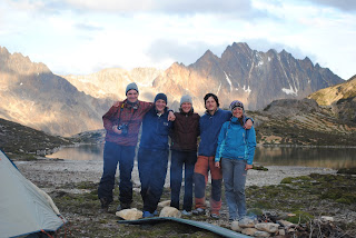
| Amy and Dave and ´their people´. |
The first day we climbed up a valley, past several more hanging glacial valleys, including our favorite glacier -- Glacier Sin Nombre - literally, Glacier Without a Name.
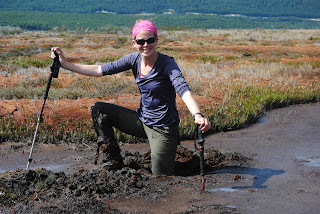
On the second day, we had more climbing, along a river valley... Dave found some deep mud very early -- the kind of mud you might need help to get out of -- about waist deep. Amy offered to help... after snapping about 20 photos of Dave´s slog. But don´t worry... Dave would have his revenge on day 4.
 |
| Amy, ever helpful... |
 |
| decided to snap a few photos... |
 |
| before offering assistance to Dave (3 of the 20 she took) |
At some point, ´where the river turned´, according to the route description in our book, we were supposed to turn uphill towards a mountain pass that would take us to the other side of the range. According to the route description, we were to look for a large boulder with a cairn on top... as it turns out, there are lots of large boulders in glacial valleys. So, we found an area where it looked like others had decided to head uphill, and headed up into the forest. Very quickly, signs of other hikers vanished, and the forest closed in around us. We pretty much headed straight uphill, through thick forest, trying to maneuver around trees, branches and roots, with our giant backpacks. We were not too upset to finally leave that forest. When we did finally climb above the tree-line, there wasn´t really a clear pass available (a lower point in the mountain ridge)... so we found the lowest point and continued to climb, and climb, and climb. Our friend Tomas joined us, having endured his own battle with the forest... although Marcel and Vanda were not visible, and we assumed, still in the forest. Eventually, we reached the summit of the mountain we were climbing... high above the valley below... high enough that the condors circled below us, rather than above us... and as we looked to the east, several hundred meters below us in elevation, lay the beautiful Lago Azul, our destination for the night.. and if you looked closely, Marcel and Vanda, who had clearly chosen the correct route. We had climbed several hundred meters of unnecessary mountain... but it really was a lovely view:)
We camped there for the night, climbed up a beautiful pass the next morning, and dropped into a high valley of lakes and stunning views. We continued over the beautiful Paso de Cinco Lagunas, and began a long descent down down down into the river valley below, hiking through the river at times because the way was clearer, and camping on a small bank/beach by the Rio Olivia.
We had thought the fourth day was going to be light and easy... we were already in the river valley and the route was very flat the rest of the way. Plus, we were several kilometers ahead of schedule, having camped farther along the trail than our planned itinerary. Didn´t exactly work out that way. We took an early detour from the ´trail´ to avoid crossing the river first thing in the morning in a futile effort to keep our boots dry (eventually, we crossed the river further downstream, and in a much deeper portion). Then we found ourselves on the wrong side of a lake (according to our route description), and the wrong side of the river... which was looking more and more uncrossable with every step. By the time we found a place in the river we could cross, we had missed the entrance to the trail through the forest that would take us to the end of the trek with ease... Instead, we hiked for about 3 hours on thick, spongy peat moss, where every step required significant effort (like walking in deep sand or snow) -- avoiding, where possible, the wetter, muddier areas... with varying degrees of success. Dave decided to head towards drier land near the forest... Amy decided to head in a straight line towards Ruta 3, which we could now see in the distance.
 |
| Mud! |
Once we reached the road, we hitched a ride back into Ushuaia for some well-earned showers.
No comments:
Post a Comment